 Summer’s dog days don’t mean crop scouting vigilance ends. Numerous events can happen post-tassel — from aphid, rootworm beetle, grasshopper feeding and nutrient deficiency to ear, leaf and stalk diseases. The challenge is determining which issues can be profitably solved in-season, while capturing what must be managed in future years.
There are many online resources, mobile apps and IPM guides on how to scout a field, what gear to use, and when to visit fields to look for specific pests in your area. In-season weekly reports from university agronomists, ag retailers, seed company agronomists and independent crop scouts usually offer good scouting advice, too.
Potential Post-Tassel Issues
It’s helpful to track plant development progress in a field. You can calculate the estimated growth stage shifts by using growing degree days (GDD) or heat units, which will vary depending on environmental stresses that impact the timeframe between vegetative and reproductive stages.

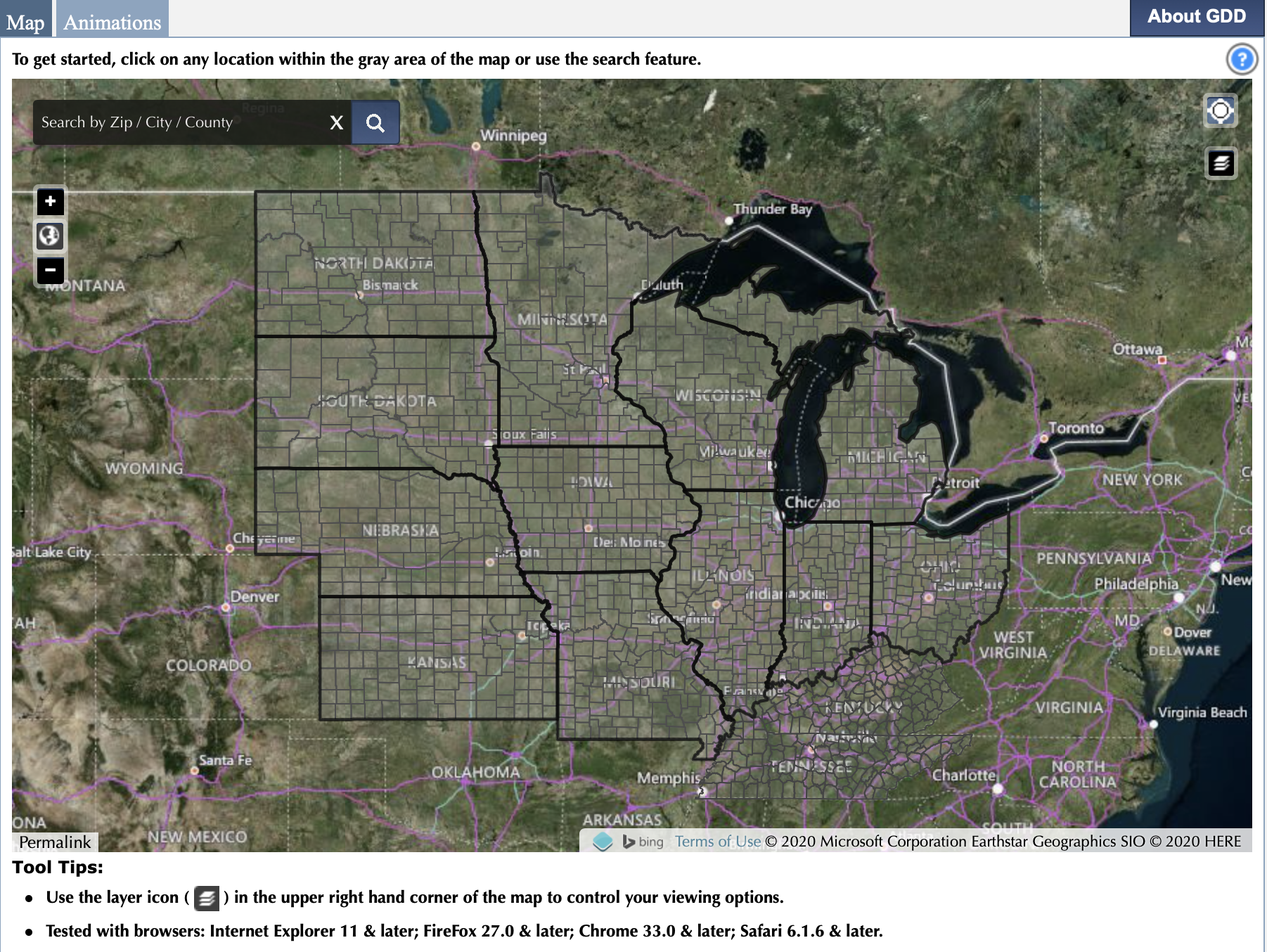
The corn U2U Corn GDD tool from the High Plains Regional Climate Center is one online source to estimate current and future GDD accumulations for 14 Midwest states. The tool calculates cumulative GDD from planting to the current date and provides estimated ranges for upcoming silking and black layer dates. Purdue University agronomist Bob Nielsen offers some good field examples in this report on predicting leaf stages.
When you enter a cornfield, be on the lookout for these potential problems by growth stage:
- V10 to VT (tasseling): Corn rootworm adults, European corn borer, corn leaf aphids, grasshopper, armyworm, foliar diseases, root lodging and green snap.
- R1 (silking): Corn rootworm adults, corn earworm, fall armyworm, Japanese beetle, foliar diseases, drought.
- R2 (blister) to R4 (dough): Foliar diseases, nutrient deficiencies, barren stalks, poor pollination, corn borer, head smut, grasshopper.
- R5 (dent) to R6 (physiological maturity): Ear rots, anthracnose top dieback, abnormal ear fill (stress), stalk rots and lodging.
Pioneer offers a mobile pest ID tool to assist with your scouting. Threat ID, part of the Pioneer Seeds App and powered by Plantix, uses a smartphone camera to recognize the most likely diseases, pests or nutrient deficiencies. Farmers can schedule consultations with their Pioneer agronomist for treatment recommendations.
Late-Season Focus
Scouting for corn rootworm (and corn borer on non-GMO corn acres) remains an important task to check for potential resistance to Bt-RW (rootworm) corn traits. If you skipped specific RW traits, opting for an insecticide or seed treatment or no treatments, be sure to log these findings to improve future cropping decisions.
If you suspect and test to prove nitrogen deficiency, healthy corn can respond to a late-season application. “The earlier the application the better, but profitable responses have been obtained as late as two to three weeks after tasseling,” writes Purdue agronomist Jim Camberato.
Regarding weeds, finding and removing late-season weeds like Palmer amaranth will pay dividends in future years. One plant can release 200,000 to 1 million seeds into the weed seedbank. Bag and remove weeds from the field to burn. If the population is too dense, mark the location and harvest that area last, followed by a thorough combine cleaning.
Aerial Imagery Aids Scouting
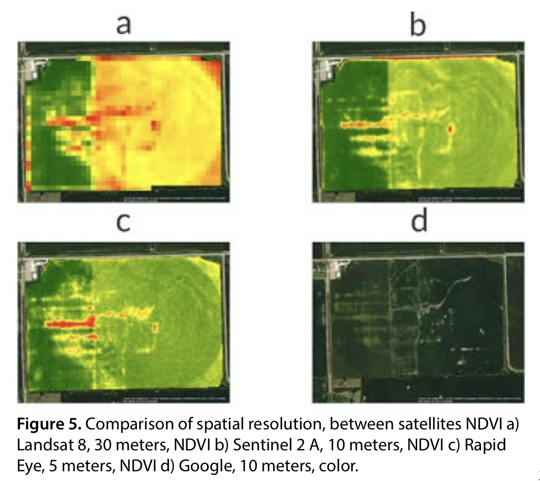
Satellite or drone imagery can give you the big picture of your fields — and maybe even expedite your time spent under the canopy.
One noted authority on imagery is Ignacio Ciampitti, farming systems specialist at Kansas State University. His KSU Crops lab in the Agronomy Department compiled “Satellite Data and Agronomic Decisions” to describe how to use satellite imagery to assist decision making.

This publication provides useful background on satellite choice and sensor use for various tasks. “Satellite images help monitor crop vegetation to diagnose potential stress factors like nutrient deficiencies, diseases, insects and drought,” Ciampitti says. “It provides more effective help when combined with boots on the ground.”
Ciampitti predicts we’ll see more site-specific management in the future using aerial-based, prescription maps for variable-rate applications of fungicides, insecticides or late nitrogen applications. “More research is needed to improve existing predictive models, and we’re working to expand our capabilities of enhancing the Predictive Ag discipline,” he says.
Numerous companies, ag retailers and crop consultants offer imagery and analysis services. Granular Insights, a Corteva company product, offers high-frequency, high-resolution satellite imagery to prioritize in-field scouting. It includes a GPS feature, Find Me, to log crop problem locations while in the field.
Build on Field History
Every scouting trip through each field should provide data you want to add to the field's record, especially information that will impact next year's crop. Note weed patches, diseases and insects, fertility issues, soil compaction areas, erosion and drainage issues, herbicide challenges, hybrid notes and more. Take these notes with you to the combine so you can GPS-mark locations of issues on field maps.
Content provided by DTN/Progressive Farmer
The More You Grow
Find expert insights on agronomics, crop protection, farm operations and more.